Monday, 5 September 2011

Chiang Mai of Thailand


 Chiang Mai is the most picturesque place in Thailand, and abounds in natural beauty. Situated in Thailand’s northern part, Chiang Mai’s interior is covered in lush tropical vegetation. This mountainous region away from the main city has many rivers and lakes and is a natural heaven for all trekkers. It has become one of the most visited trekking hubs of the world.
chiang-mai-trekking
   The mountains are dotted with fascinating tribal villages. The tribal people are hospitable and lead a simple rural life, growing their own crops for their sustenance. Colorfully dressed and having certain strange customs, these tribal’s have retained their innocence and culture by staying away from mainstream Thailand. While on a trek, you can also stay in their house and learn about their culture and simple ways of living.

  However, if you are skeptical, then you can refer to a list of licensed agencies which is published by the Tourism Authority of Thailand.companies. Most guest houses too, provide trekking activities. You can book your treks from such places, and you will be provided with a registered guide who is well aware of the routes.


  Most of these companies run a well- organized and safe trek. In Chiang Mai, areas like Night Bazaar, Loi Kroh and Moon Muang have numerous small offices of various trekking. Treks are usually for a period of 3 to 5 days. Treks might even include an elephant ride or riding a raft down the river. These treks will involve a lot of walking and you should be reasonably fit and willing to rough it out a bit. A small backpack, which is light and not over-stuffed with clothing, is advisable. Take along a warm jacket if you are trekking in the winter months. Baht is the local currency, and a trek with a good company will cost you around 500 Bahts for a day. All meals and basic hut accommodation is included in this fee. Other activities like elephant ride and river rafting will cost more.


mae-ya-waterfall-in-chiang-maiTrekking in Chiang Mai is the best in the months from November to February. In these months the climate is pleasant during the day and the vegetation is lush. The nights might be a little chilly. If you are a person who enjoys trekking in the rain then June to September would be the best time. In these months proper rain gear is a must. The months of March, April and May are not good for trekking as there is a haze covering all the natural beauty and the spectacular views.


   The Chiang Dao area in northern Chiang Mai is considered one on the best trekking areas. Two very vast National Parks abounding in natural beauty make this place a safe and beautiful place to trek. The added attractions here are the many elephant center providing an enjoyable elephant ride. This place is also a home to many ethnic tribal communities.

World's Longest Underwater Cave System in Mexico


The Yucatan peninsula remains one of the most popular travel destinations in Mexico with visitors from around the world. Most tourists can be found on the white sand beaches and in the crystal clear waters on the Caribbean side, it is popular for cave diving as well especially now that Nohoch Nah Chich, the world’s longest underwater cave system has been discovered near near Tulum, Mexico.
longestcave zoom 45
 
 British cave diver Steve Bogaerts said he and Robbie Schmittner, of Germany, have found flooded underground passages connecting this cave system with the Sac Actun cave system, a discovery that shows how interconnected and vulnerable the Yucatan’s underground water system is.


   For thousands of years, Mayan Indians depended on water found in the caves and in lakes formed by sinkhole. Now that we know that the water systems are interconnected, it means that pollution in one can easily spread to all.Bogaerts and Schmittner spent four years swimming the length of the system, making about 500 dives with scuba tanks, linking one sinkhole lake to the next.

Grand Canyon


Grand Canyon ialah sebuah gaung yang amat curam dan berwarna-warni yang diukir oleh Sungai Colorado di negeri Arizona, Amerika Syarikat. Sebahagian besarnya terangkum dalam Taman Negara Grand Canyon — salah satu taman negara yang awal di Amerika Syarikat. Presiden Theodore Roosevelt ialah penyokong utama kawasan Grand Canyon dan yang banyak kali mengunjunginya untuk memburu serta untuk menikmati pemandangannya.
   Grand Canyon dicipta oleh Sungai Colorado yang memotong sebatang saluran melebihi enam juta tahun dahulu. Ngarai ini 277 batu (446 kilometer) panjangnya, dengan lebarnya 4 - 18 batu (6.4 - 24 kilometer) dan dalamnya melebihi sebatu (1.6 kilometer). Hampir dua bilion tahun sejarah Bumi didedahkan ketika Sungai Colorado dan cawang-cawangnya memotong lapisan demi lapisan enapan apabila penara-penara Colorado terjulang.
   Penglihatan tercatat Grand Canyon yang pertama oleh seorang Eropah adalah pada  tahun 1540 oleh García López de Cárdenas dari Sepanyol. Grand Canyon umumnya tidak diketahui sehingga selepas Perang Saudara Amerika Syarikat. Pada tahun 1869, Mejar John Wesley Powell, seorang bekas perajurit Perang Saudara satu tangan yang haus akan sains dan pengembaraan, membuat perjalanan perintis merentasi Grand Canyon melalui Sungai Colorado. Beliau mencapai perbuatan ini bersama-sama sembilan orang lelaki di dalam empat bot papan, walaupun hanya enam lelaki menyiapkan perjalanan mereka. 
   Sejauh yang diketahui, kumpulan ini merupakan kumpulan pertama yang pernah membuat perjalanan sebegini. Powell merujuk kepada batuan-batuan enap sebagai "halaman-halaman sebuah buku cerita yang agung". Jauh sebelum itu, kawasan Grand Canyon dihuni oleh orang asli Amerika yang membina petempatan-petempatan mereka di dalam tembok ngarai serta gua-guanya.

Saturday, 3 September 2011

Hutan Tropika


Hutan Tropika termasuklah hutan hujan malar hijau di garis lintang khatulistiwa dan hutan monsun tropika. Di hutan khatulistiwa pokok-pokok biasanya menggugurkan daunnya sedikit-sedikit ataupun menggugurkan daunnya mengikut musim tetapi kebanyakan daripada pokok itu mempunyai daunnya hampir seluruh masa dan sebab itu hutan ini kelihatan malar hijau. Di hutan monsun pokok-pokok ialah jenis daun-luruh yang menggugurkan daunnya pada musim kemarau dan tidak mengeluarkan daun baru sehingga musim hujan tiba.
   Isu sumber hutan tropika begitu mendapat perhatian di kalangan warga dunia terutama sekali dari negara-negara maju. Kebetulan pula sumber hutan ini tidak kedapatan di negara mereka, sebaliknya di negara bekas jajahan mereka iaitu negara sedang membangun. Kritikan dari negara maju begitu terasa terutama sekali dari kerajaan mereka dan pertubuhan yang terdapat di negara-negara tersebut.
   Hutan hujan tropika terletak di garisan lintang khatulistiwa yang suhunya panas dan lembab sepanjang tahun. Ia memerlukan suhu 18-30 °C dan hujan antara 200-300 sentimeter setahun. Hutan ini terletak di Afrika Tengah, Amerika Selatan, Amerika Tengah dan Asia Kepulauan Pasifik.
   Antara sumber hutan yang terpenting ialah jenis hutan dipterokarp. Keluarga dipterokarp ada lebih 16 jenis dan 550 species. Pusat utamanya ialah di Borneo. Lain-lain ialah di Sumatera, Semenanjung Malaysia, Jawa, Nusa Tenggara, Filipina, Sulawesi, Maluku, New Guinea dan Kepulauan Solomon. Dalam hal ini hutan dipterokarp di Filipina telah habis ditebang.

Angel Falls


Angel Falls (Spanish: Salto ÁngelPemon language: Kerepakupai Vená, meaning "waterfall of the deepest place", or Parakupá Vená, meaning "the fall from the highest point") is a waterfall in Venezuela.
It is the world's highest waterfall, with a height of 979 m (3,212 ft) and a plunge of 807 m (2,648 ft). The waterfall drops over the edge of the Auyantepui mountain in the Canaima National Park (Spanish: Parque Nacional Canaima), a UNESCO World Heritage site in the Gran Sabana region of Bolívar State. The height figure 979 m (3,212 ft) mostly consists of the main plunge but also includes about 400 m (0.25 mi) of sloped cascades and rapids below the drop and a 30 m (98 ft) high plunge downstream of the talus rapids.
The base of the falls feeds into the Kerep River (alternatively known as the Río Gauya), which flows into the Churun River, a tributary of the Carrao River. Before reaching the ground, much of the water is dissipated as mist.
   Angel Falls is one of Venezuela's top tourist attractions, though a trip to the falls is a complicated affair. The falls are located in an isolated jungle, and a flight from Puerto Ordaz or Ciudad Bolívar is required to reach Canaima camp, the starting point for river trips to the base of the falls. River trips generally take place from June to December, when the rivers are deep enough for the wooden curiaras used by the Pemon guides. During the dry season (December to March) there is less water seen than in the other months (this can be clearly seen in the photos of the falls above).
In 2009 was nominated to compete in the New 7 Wonders of Nature, reaching third place of the 77 most voted wonders in the world. Angel Falls entered the final group of the 28 most popular and now is among the first in the ranking.
Partly clouded view during the end of the dry season.

A Famosa


Portadesantiago.jpg
A Famosa (Kota A Famosa; "The Famous" in Portuguese) is a Portuguese fortress located in Malacca, Malaysia. It is among the oldest surviving European architectural remains in Asia. The Porta de Santiago, a small gate house, is the only remaining part of the fortress still standing.

   In 1511, a Portuguese fleet arrived under the command of Afonso de Albuquerque. His forces attacked and successfully defeated the armies of the Malacca Sultanate. Moving quickly to consolidate his gains, Albuquerque had the fortress built around a natural hill near the sea. Albuquerque believed that Malacca would become an important port linking Portugal to the Spice Route in China. At this time otherPortuguese were establishing outposts in such places as Macau, China and Goa,India in order to create a string of friendly ports for ships heading to China and returning home to Portugal.

  The fortress once consisted of long ramparts and four major towers. One was a four-story keep, while the others held an ammunition storage room, the residence of thecaptain, and an officers' quarters. Most of the village clustered in town houses inside the fortress walls. As Malacca's population expanded it outgrew the original fort and extensions were added around 1586.


   The fort changed hands in 1641 when the Dutch successfully drove the Portugueseout of Malacca. The Dutch renovated the gate in 1670, which explains the logo "ANNO 1670" inscribed on the gate's arch. Above the arch is a bas-relief logo of theDutch East India Company.

   The fortress changed hands again in the early 19th century when the Dutch handed it over to the British to prevent it from falling into the hands of Napoleon's expansionist France. The English were wary of maintaining the fortification and ordered its destruction in 1806. The fort was almost totally demolished but for the timely intervention of Sir Stamford Raffles, the founder of Singapore, who happened to visit Malacca in 1810. Because of his passion for history, this small gate was spared from destruction.

Monday, 22 August 2011

Seven Wonders Of The Ancient World


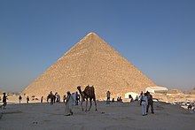
The seven wonders that are most widely agreed upon as being in the original list are the Seven Wonders of the Ancient World, which was compiled by ancient Greek historians and is thus confined to the most magnificent structures known to the ancient Greek world. Of all the Ancient Wonders, the pyramids alone survive.

   The Pyramids of Egypt are three pyramids at Giza, outside modern Cairo. The largest pyramid, built by Khufu (Cheops), a king of the fourth dynasty, had an original estimated height of 482 ft (now approximately 450 ft). The base has sides 755 ft long. It contains 2,300,000 blocks; the average weight of each is 2.5 tons. Estimated date of completion is 2680 B.C.


  The Hanging Gardens of Babylon were supposedly built by Nebuchadnezzar around 600 B.C. to please his queen, Amuhia. They are also associated with the mythical Assyrian queen Semiramis. Archeologists surmise that the gardens were laid out atop a vaulted building, with provisions for raising water. The terraces were said to rise from 75 to 300 ft.


   The Statue of Zeus (Jupiter) at Olympia was made of gold and ivory by the Greek sculptor Phidias (5th century B.C.). Reputed to be 40 ft high, the statue has been lost without a trace, except for reproductions on coins.


   The Temple of Artemis (Diana) at Ephesus was begun about 350 B.C., in honor of a non-Hellenic goddess who later became identified with the Greek goddess of the same name. The temple, with Ionic columns 60 ft high, was destroyed by invading Goths in A.D. 262.


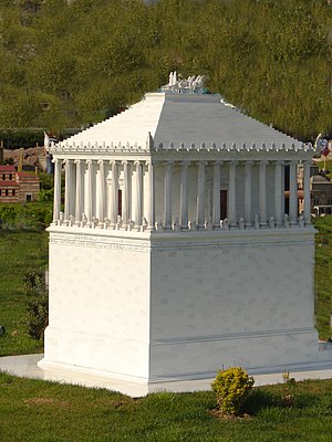
  The Mausoleum at Halicarnassus was erected by Queen Artemisia in memory of her husband, King Mausolus of Caria in Asia Minor, who died in 353 B.C. Some remains of the structure are in the British Museum. This shrine is the source of the modern word mausoleum.


 The Colossus at Rhodes was a bronze statue of Helios (Apollo), about 105 ft high. The work of the sculptor Chares, who reputedly labored for 12 years before completing it in 280 B.C., it was destroyed during an earthquake in 224 B.C.


Lighthouse - Thiersch.gif   The Pharos (Lighthouse) of Alexandria was built by Sostratus of Cnidus during the 3rd century B.C. on the island of Pharos off the coast of Egypt. It was destroyed by an earthquake in the 13th century.

Wednesday, 10 August 2011

Keunikan Etnik Sarawak

Sarawak adalah negeri yang sangat cantik. Sarawak memang cukup dikenali sebagai negeri yang mempunyai kaum yang sukar untuk didapati di tempat-tempat lain. 


Untuk mengetahui latar belakang serta kepelbagaian etnik yang terdapat di Sarawak, rasanya tidak cukup jika sekadar dengan membaca buku tanpa melihat sendiri gaya hidup serta suasana penempatan kaum-kaum tersebut.


Jom Kenali Keunikan Etnik Sarawak Di Kampung Budaya Sarawak Oleh sebab itu, Kampung Budaya Sarawak yang dibuka secara rasmi pada tahun 1990 dan dibangunkan di atas tanah seluas 14 ekar diharap mampu memberikan pengalaman terindah kepada pengunjung yang mahu merasai sendiri gaya hidup serta kediaman sebenar masyarakat unik tersebut.
Jom Kenali Keunikan Etnik Sarawak Di Kampung Budaya Sarawak


Hanya 35 kilometer dari Bandaraya Kuching dan mengambil masa lebih kurang 35 minit perjalanan menggunakan kereta, Kampung Budaya Sarawak merupakan lokasi percutian terbaik untuk seisi keluarga.


"Walaupun dikenakan bayaran sebanyak RM60 untuk golongan dewasa dan RM30 untuk kanak- kanak, namun saya rasa ianya cukup berbaloi kerana pengalaman sebegini sukar untuk didapati di tempat lain.
TJom Kenali Keunikan Etnik Sarawak Di Kampung Budaya Sarawak"Apatah lagi saya diberitahu kebanyakan kaum-kaum minoriti di Sarawak seperti kaum Bidayuh, Iban, Penan, Orang Ulu dan Melanau juga kini sedang dilanda era kemodenan. Jadi mereka sudah tidak tinggal di dalam rumah yang bercirikan tradisional seperti ini.


"Di Kampung Budaya Sarawak ini, kami dipaparkan dengan gaya hidup sebenar masyarakat tersebut termasuklah kuih muih, pakaian tradisional serta tarian yang dipersembahkan di dalam persembahan kebudayaan selama 45 minit yang diadakan khusus untuk pengunjung.


Jom Kenali Keunikan Etnik Sarawak Di Kampung Budaya Sarawak

"Pendek kata Kampung Budaya Sarawak ibarat sebuah 'muzium hidup' yang penuh warna warni kehidupan masyarakat desa," ujar salah seorang pelancong tempatan yang hanya mahu dikenali sebagai Faizal.


Beliau yang berasal dari Kuala Lumpur memberitahu, anak-anaknya cukup teruja kerana berpeluang memasuki rumah kaum Melanau yang sangat tinggi serta kaum Bidayuh yang berbentuk bulat.


TJom Kenali Keunikan Etnik Sarawak Di Kampung Budaya Sarawak   
Tambah manis apabila para pekerja di Kampung Budaya Sarawak memberikan layanan yang baik dan mesra kepada para pelancong. "Berlatar belakangkan hutan hujan tropika yang masih elok terpelihara serta Gunung Santubong yang tinggi melangit, saya yakin Kampung Budaya Sarawak akan terus dikenali sehingga ke peringkat antarabangsa," tambahnya.


   Dibuka setiap hari bermula jam 9.00 pagi hingga 5.15 petang, Kampung Budaya Sarawak yang telah menerima pelbagai anugerah dari dalam luar negara itu diharapkan akan terus terpelihara serta menjadi daya tarikan utama buat para pelancong yang mahu berkunjung ke Sarawak.

Monday, 8 August 2011

Sarawak Bumi Kenyalang


Negeri Sarawak dikenali dengan gelaran Bumi Kenyalang merupakan salah satu daripada 14 negeri yang membentuk Persekutuan Malaysia. Burung Kenyalang (Rhinoceros Hornbill) merupakan burung rasmi negeri Sarawak. 

   Oleh kerana spesies Burung Kenyalang ini yang hanya boleh didapati di negeri ini, Sarawak turut dikenali sebagai Bumi Kenyalang (Land of the Hornbill). Sengalang Burong yang memainkan peranan yang penting dalam perayaan keagamaan Iban, terutamanya Hari Gawai Kenyalang.

   Bagi sesetengah penduduk Dayak, burung Enggang Badak mewakili Dewa Perang mereka, Singalang Burong. Ia merupakan burung negeri Sarawak. Burung Kenyalang ini melambangkan satu daripada 'Petara'[Tuhan] yang paling berkuasa dalam kaum Dayak,

   Kenyalang mengemari buah ara dan memain peranan dalam penghapusan buah ara – suatu proses yang menujukan penumbuhan penghutanan ekosistem Sarawak.